Madrid’s Metropolitan Turn: Governing Urban Harmony in Contemporary Europe

By Efthymios Georgiou (e-mail)
Introduction
Madrid is one of the largest cities in Europe, with its municipality and metropolitan area functioning as major political, economic, and cultural centres for both Spain and the wider European continent. In recent decades, European urban policies and Madrid’s strategic position vis-à-vis global cities such as Paris and London have fostered new trends in urban governance and administrative practice.
Cultural authenticity, environmental sustainability, green infrastructure, urban mobility, air pollution reduction, and energy self-sufficiency are the primary pillars of Madrid’s urban development strategy. These priorities reflect a democratic and inclusive approach to local governance, aimed at improving the quality of life and addressing contemporary environmental and social challenges. Figure 1 presents a timeline of urban transformation in London, Paris, and Madrid during the Renaissance. The emergence of capitalism and the development of national identity have played significant roles in shaping city planning across Western civilisation.
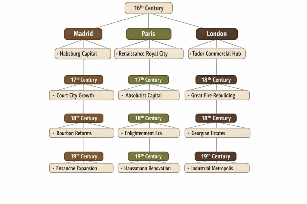
Figure 1: A Tree Diagram of Urban Transformation (16th–19th c.)
Fundamental Principles of European Architectural Tradition
London, Paris, and Madrid exemplify three distinct trajectories in European urban development, shaped by differing political structures, economic transformations, and planning ideologies over time (Hall, 1988; Kostof, 1991).
Urban Planning and Spatial Governance in London
London serves as a model of organic metropolitan growth, marked by incremental adaptation rather than comprehensive redesign. From its origins as the Roman settlement of Londinium, through medieval mercantile expansion and the post-1666 reconstruction under experts such as Christopher Wren, the city evolved via successive interventions that preserved irregular street patterns while incorporating modern infrastructure (Ackroyd, 2000). The emergence of Georgian squares and Victorian rail networks during the eighteenth and nineteenth centuries further consolidated London’s polycentric structure, which later expanded through suburban development influenced by Ebenezer Howard’s Garden City principles (Hall, 1988).
The Morphological and Socio-Spatial Evolution of Paris
Paris serves as a prominent example of centralised, state-directed urban transformation. Although the medieval core remained concentrated around the Île de la Cité, the most substantial changes occurred during the Second Empire, when Georges‑Eugène Haussmann, under the direction of Napoleon III, oversaw a comprehensive modernisation program. This initiative introduced wide boulevards, monumental vistas, advanced sanitation systems, and uniform architectural styles, which enhanced the legibility, hygiene, and symbolic significance of Paris (Pinkney, 1958; Jones, 2004). Haussmannization not only improved circulation and public health but also reinforced mechanisms of social control and imperial representation, establishing a model that influenced urban planning practices internationally (Kostof, 1991).
Urban Culture in Renaissance Madrid
Madrid constitutes an intermediate case, defined by the juxtaposition of an irregular historic nucleus and a systematically planned nineteenth-century expansion. Following its establishment as Spain’s permanent capital in the sixteenth century, the city developed primarily as a royal administrative centre with minimal industrialisation. The 1860 Ensanche plan, designed by Carlos María de Castro, introduced a rational grid intended for bourgeois residential development and drew upon contemporary planning concepts, notably those of Ildefons Cerdà (Capel, 1975). Consequently, Madrid’s present urban form displays a hybrid morphology in which monarchical institutions, planned boulevards, and modern metropolitan infrastructure coexist with a dense historic core (Graham, 2009). Taken together, these three capitals illustrate how urban morphology functions as a spatial archive of governance, ideology, and socio-economic transformation in Europe.
Atlas of the Madrid Metropolitan Region
The maps illustrate the locations of urban regeneration projects in Madrid. These visualisations were produced in ArcGIS Pro using a five-year classification scheme spanning 2005 to 2030, with distinct colours assigned to each interval. The spatial distribution of projects encompasses the entire Madrid metropolitan area, with a primary concentration in the city center. The maps present the geographic coordinates (latitude and longitude) of urban regeneration initiatives within the metropolitan area of Madrid.
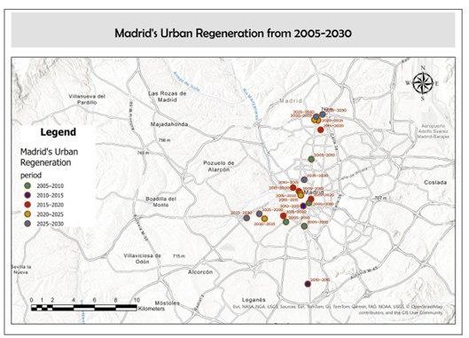
Figure 2: Madrid’s Urban Regeneration from 2005-2030
Trends in Urban Regeneration over the Past Half-Decade
Madrid has sustained a continuous tradition of architectural and urban planning since the Renaissance, facilitating an ongoing interaction between its historical legacy and contemporary innovation. As Spain’s capital, the city integrates its extensive architectural heritage with the evolving demands of modern urban life. Recent urban planning strategies in Madrid emphasize sustainability and social inclusion. Major development initiatives prioritise energy efficiency, gender-responsive planning, improved cycling and pedestrian infrastructure, comprehensive housing policies, and regulation of urban density and overcrowding. Collectively, these strategies establish Madrid as a progressive model that balances historical continuity with innovative urban governance.
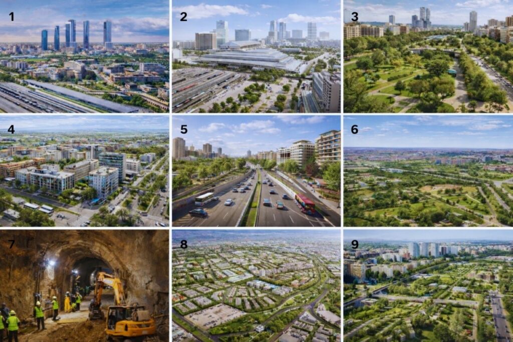
Figure 3: Urban Projects
1) Madrid Nuevo Norte (formerly Operación Chamartín)
Madrid Nuevo Norte is the first urban project in Europe to achieve both LEED and BREEAM pre-certifications. Urbanisation in the Las Tablas Oeste area is scheduled to begin in the second quarter of 2026. The project redevelops extensive former railway lands surrounding Chamartín into a mixed-use district that includes offices, residential units, public facilities, and significant green spaces. Insights from this case study inform policy development and decision-making in urban development, public-private partnerships, and sustainable city planning (Metaxas, T., Gallego, J. S., & Juarez, L., 2023).
Spanish policy frameworks prioritise indicators aligned with the Sustainable Development Goals (SDGs). The project’s life cycle has generated substantial economic activity in Spanish localities, with a focus on water management objectives (SDG 6) and a strong emphasis on SDG 5 (Gender Equality), highlighting the pervasive importance of gender equality in policy implementation (Álvarez-Melcón, I., Sisto, R., et al., 2024).
The project demonstrates how the legal and discursive production of space reveals tensions among urban governance, the right to the city, and socio-spatial justice (Prieto Fernández, I., 2025). SDG 7 is also a key concern for Spanish municipalities. The Clean Energy Transition serves as a central policy driver in Spain, encompassing renewable energy adoption, energy efficiency, and electromobility (Álvarez-Melcón, I., Sisto, R., et al., 2024). Limited engagement with residents and associations has resulted in official communications and plans that are disconnected from citizens’ needs and environmental sustainability (Canosa Zamora, E., & García Carballo, Á., 2018). Due to the predominantly urban character of the studied localities, SDG 11 (Sustainable Cities and Communities) is strongly represented in the dataset. Local governments, which have authority over urban planning and management, are well-positioned to address these dimensions (Álvarez-Melcón, I., Sisto, R., et al., 2024). Madrid Nuevo Norte exemplifies a strategic shift toward polycentric metropolitan growth in Madrid.
2) Chamartín Station Comprehensive Redevelopment
The modernisation of Chamartín Station establishes it as a major international transport hub for high-speed rail, commuter lines, metro, and bus services. Increased capacity enables the expansion of Spain’s AVE network and supports future cross-border connections.
Following the remodelling, the station building will expand from 120,000 to 180,000 square meters. Ten new tracks will be added to the existing 21, with 13 designated for commuter trains and 18 for high-speed and long-distance services. As a result of this expansion, Chamartín is projected to accommodate approximately 22 million passengers annually (Esteban, C. G., 2020).
The architectural redesign emphasises efficient passenger circulation, intermodality, and integration with the surrounding urban environment. Chamartín Station serves as the primary mobility node for Madrid Nuevo Norte. This redevelopment demonstrates the potential of transport infrastructure to drive large-scale urban transformation.
3) Paseo de la Castellana Undergrounding & New Park
The proposal to underground the northern section of Paseo de la Castellana aims to reduce traffic barriers and reclaim surface space for public use. Enclosing the roadway infrastructure would facilitate the creation of parks, pedestrian zones, and new urban connections. This intervention is expected to enhance environmental quality and strengthen connections between the business district and adjacent neighbourhoods. Furthermore, it reinforces the symbolic importance of Castellana as Madrid’s principal north–south axis. The project aligns with current priorities in sustainability and urban livability.
4) Las Tablas Oeste Development
Las Tablas Oeste is one of the initial urbanised sectors in Madrid Nuevo Norte, where construction is currently underway. The development emphasises residential functions, dedicating a significant portion to affordable housing. Planned amenities encompass new schools, essential services, and green spaces, with the objective of creating a self-sufficient neighbourhood rather than a dormitory suburb. The grid layout reflects contemporary planning principles that emphasise walkability and local accessibility. This project illustrates Madrid’s broader strategy to meet housing demand during the city’s northern expansion.
5) A-5 Corridor Transformation (Campamento Area)
The A-5 corridor transformation aims to convert a highway-dominated entrance into an urban, human-scale environment. The project employs strategies to reduce surface traffic, enhance public transportation, and redevelop adjacent military lands in Campamento for residential use. This regeneration initiative seeks to reconnect Western districts that were previously separated by infrastructure barriers. Progress continues on converting the A-5 into an urban boulevard. The undergrounding of 3.2 kilometres of the highway is expected to be completed by late 2026 or spring 2027, thereby eliminating the “wall” effect between the Latina and Casa de Campo districts. The primary objectives are environmental enhancement and noise reduction. This project reflects a broader European trend of repurposing urban highways for civic purposes.
6) Metro de Madrid Line 11 Extension
The extension of Metro Line 11 constitutes a significant infrastructure investment aimed at improving orbital connectivity throughout Madrid. Known as the “Diagonal Line,” the project had reached approximately 43% completion between Comillas and Conde de Casal by early 2026, with the “Mayrit” tunnel boring machine (TBM) in operation. The addition of new stations will serve emerging districts such as Valdebebas and reinforce connections to the airport and northern areas. Improved accessibility is expected to benefit both established neighbourhoods and zones designated for urban expansion. Furthermore, the project aims to decrease reliance on private vehicles. This infrastructure-driven regeneration forms a core component of Madrid’s sustainable mobility strategy.
7) Valdecarros / Madrid East Development
Valdecarros represents one of the largest planned urban extensions in Europe and is situated on the southeastern periphery of Madrid. The project aims to provide tens of thousands of housing units, along with transport infrastructure, parks, and essential services. Developed as a long-term strategy to address population growth and housing shortages, Valdecarros is projected to become one of Spain’s largest affordable housing centres. The first stage of urbanisation is approaching 95% completion, with initial residential construction scheduled to begin this year. The development will advance in phases over several decades. Although located on the periphery, Valdecarros is anticipated to significantly influence the future metropolitan structure of Madrid.
8) Rail-Yard Covering & Green Integration South of Chamartín
The proposed coverage of rail infrastructure south of Chamartín seeks to eliminate physical barriers that have historically fragmented adjacent neighbourhoods. A direct comparison to the Madrid Río project is instructive, as it serves as the ideological precursor to the current A-5 and Castellana undergrounding initiatives. The development of new parks and public spaces over the tracks will create a continuous urban fabric. This strategy is expected to improve environmental conditions and increase the amount of land available for development. Additionally, it will enhance pedestrian connectivity across previously inaccessible areas. Similar decking strategies are increasingly implemented in dense urban environments to reclaim infrastructural land for civic purposes.
Designing Climate-Responsive and Resource-Efficient Cities
Contemporary urban governance encounters numerous emerging challenges. Key policy priorities for the future include climate action, environmental adaptation, building restoration, harmonising planning regulations between historic preservation and modern urban planning, nature conservation, air pollution reduction, and enhancing walkability in daily urban life.
References
Álvarez-Melcón, I., Sisto, R., Rodríguez, Á. D. J., & Pereira, D. (2024). Integrating the SDGs into urban regeneration: A Madrid Nuevo Norte case study using an adapted voluntary local review framework. Sustainability, 16(22), 9727. https://doi.org/10.3390/su16229727
Ackroyd, P. (2000). London: The biography. Chatto & Windus.
Canosa Zamora, E., & García Carballo, Á. (2018). The failure of eco-neighborhood projects in the city of Madrid (Spain). Urban Science, 2(4), 111. https://doi.org/10.3390/urbansci2040111
Capel, H. (1975). Capitalismo y morfología urbana en España. Los Libros de la Frontera.
Graham, H. (2009). Madrid: A cultural history. Oxford University Press.
Esteban, C. G. (2020). Reconversión discutida: Nuevos paisajes en Chamartín. In Cultura y naturaleza en Madrid. Estrategias para el siglo XXI: Ciclo de conferencias (pp. 125-149). Instituto de Estudios Madrileños.
Hall, P. (1988). Cities of tomorrow. Blackwell.
Jones, C. (2004). Paris: The life of a great city. Penguin.
Kostof, S. (1991). The city shaped: Urban patterns and meanings through history. Thames & Hudson.
Metaxas, T., Gallego, J. S., & Juarez, L. (2023). Sustainable urban development and the role of mega-projects: Experts’ view about Madrid Nuevo Norte Project. Journal of Infrastructure, Policy and Development, 7(2), 2161.
Pinkney, D. H. (1958). Napoleon III and the rebuilding of Paris. Princeton University Press.
Prieto Fernández, I. (2025). Between the global and the local: Socio-legal articulations of Madrid Nuevo Norte Project.
Also read by Efthymios Georgiou in the Regions:
Berlin’s Digital Geographies: Mapping Green Futures in the 21st Century