Berlin’s Digital Geographies: Mapping Green Futures in the 21st Century
DOI reference: 10.1080/13673882.2025.12533895
By Efthymios Georgiou (e-mail)
The Political Mirror of Berlin
Berlin is both a city and a federal state within Germany, located in the heart of Europe. Since its reunification in 1990, it has been the national capital and is the most populous urban centre in the country, with an estimated 3.4 million residents by 2025 (Arandelovic & Bogunovich, 2014). Berlin joined the European Union on 3 October 1990 and plays a vital role in EU policymaking and governance. Its participation in the Schengen Agreement, which allows for border-free movement, further integrates it within Europe. Additionally, Berlin is involved in international networks like the United Nations, G7, G20, Euro cities, and the C40 Cities Climate Leadership Group, underscoring its importance as a hub for political collaboration and sustainable urban development.
Cultural and City Heritage
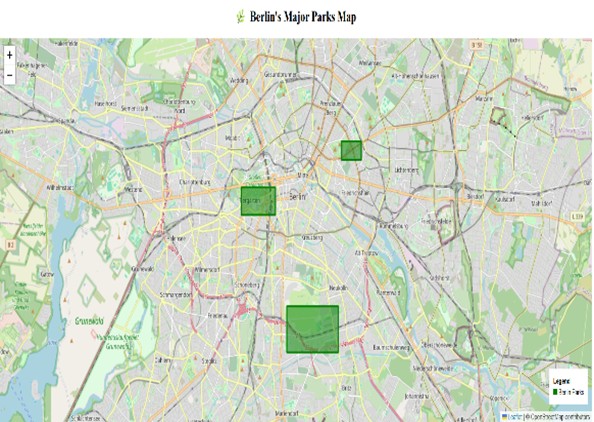
Berlin stands as a dynamic and vibrant city, celebrated for its rich cultural heritage and recognised as one of the prestigious UNESCO Cities of Design. As Germany’s capital, it is home to a wealth of cultural institutions that reflect its artistic spirit (Arandelovic & Bogunovich, 2014). Pioneering filmmakers like Walter Ruttmann and Dziga Vertov revolutionised the cinematic experience by capturing the essence of urban life, which ignited a robust new discourse in cultural criticism (Presner, T., 2010). Figures 1 and 2, crafted using HTML and the innovative open-source Leaflet.js library, showcase the beauty and complexity of Berlin’s landscape through web-based geospatial visualisation.
Figure 1
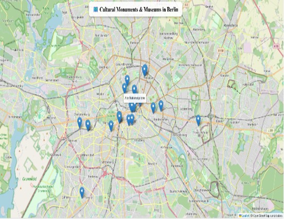
Figure 1 effectively maps the spatial distribution of 30 cultural monuments and museums across the city. In contrast, Figure 2 emphasises the significance of three major urban parks, spotlighting essential green spaces within Berlin’s metropolitan area. Leaflet is a cutting-edge JavaScript library that empowers users to create interactive web-based mapping applications with remarkable ease and precision. When seamlessly integrated into a web programming environment, it unlocks the potential for dynamic and engaging spatial visualisations. By leveraging tools like Notepad++, users can design a diverse range of thematic maps that span multiple domains, including environmental, cultural, tourism, economic, social, and transportation issues.
Figure 2
Environmental Heritage
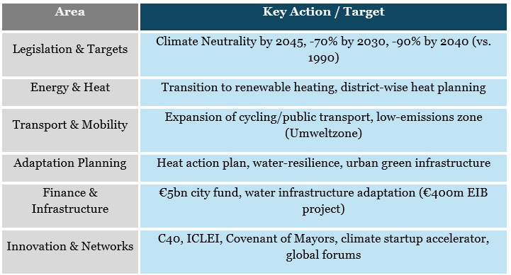
The European Green Deal must be supported by a thorough evaluation of the environmental and climatic impacts of all relevant policy frameworks, particularly those that have significant ecological effects (EU Decision, 2020). The incorporation of environmental indices provides reliable, evidence-based insights and encourages a system-oriented, interdisciplinary approach to environmental governance. On June 24, 2021, the European Parliament officially adopted the EU Climate Law, which establishes a legally binding commitment to reduce greenhouse gas emissions by 55% by 2030 and achieve climate neutrality by 2050 (EU Green Deal, 2024). In response to the European Commission’s political decisions on climate change, Berlin has outlined its priorities and actions. Table 1 summarises the key areas of development policies along with their respective actions and goals.
Figure 3: Mauer Park, Gleimstraße
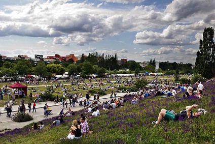
Source: https://www.touropia.com/the-7-coolest-parks-in-berlin/
Table 1
Recommendations for practices
The protection of the environment and culture in Berlin is a crucial aspect of sustainable development. In today’s digital era, we face new challenges. To address these, we can utilise scientific tools such as web maps, 3D models, statistical visualisations, and the public sharing of nature’s beauty on social media. However, implementing these ideas requires effective decision-making to turn them into reality.
- Web Cartography
Since 2005, Internet mapping technologies have undergone significant evolution, marked by the development of innovative methodologies and the introduction of new terminologies within the geospatial field (Haklay, Singleton, & Parker, 2008). The Leaflet.js library has emerged as a powerful and lightweight web mapping framework, transforming traditional topographic maps into interactive, browser-based geospatial platforms that enhance user accessibility, engagement, and analytical capabilities (Horbiński & Lorek, 2022). Numerous case studies demonstrate the key features of this technological shift, often referred to as Web Mapping 2.0, and highlight its differences from earlier versions of online cartographic systems. These innovations not only push the technical boundaries of geographic information science but also raise important questions for the broader fields of geography and how society interacts with spatial data (Haklay, Singleton, & Parker, 2008).
- Three-Dimensional Model of Landscape
Landscape ecology in urban environments is a key area of contemporary geographical research (Chen et al., 2014). In cartography, various methodologies address map generalisation, involving complex spatial decision-making and abstraction (Lal & Meng, 2001). The application of 3D landscape metrics highlights the importance of vertical structural patterns in analysis (Chen et al., 2014). Three-dimensional geospatial modelling relies on foundational datasets that include topography, land use, hydrographic networks, transportation infrastructure, built environments, and tourism facilities. Additionally, remote sensing data, such as satellite imagery, orthophotos, radar, and LiDAR, are crucial for accurate spatial modelling (Dinkov & Vatseva, 2016).
- Measurement and Visualisation of Statistical Indexes
The combination of statistical indicators and geospatial visualisation enables researchers and policymakers to evaluate socio-economic, environmental, and health conditions with enhanced spatial accuracy. Effective data visualisation aids evidence-based decision-making by emphasising correlations and regional disparities in key indicators.
- Promoting the Environmental Heritage on Social Media
The United Nations’ Sustainable Development Goals (SDGs) 8 and 11 focus on essential aspects of heritage and sustainable tourism. SDG 11.4 emphasises the protection and preservation of cultural heritage, while SDG 8.9 aims to promote sustainable tourism that creates jobs and supports local culture and products. (Xiao, W., Mills, J., Guidi, G., Rodríguez-Gonzálvez, et al., 2018). The Climate Heritage Network recognises that the arts, culture, and heritage are invaluable resources for enabling communities to take transformative climate action. Today, a variety of stakeholders can contribute to the promotion and preservation of environmental heritage.
Conclusion
The contemporary digital era marks a significant transformation in the evolution of global society. Technological tools are essential for advancing initiatives aimed at peaceful and constructive goals. Specifically, protecting cultural and environmental heritage is a fundamental aspect of promoting planetary sustainability and ensuring long-term ecological security. The health of our planet is closely linked to human health, as illustrated by indicators such as air quality, nitrogen dioxide (NO₂) levels, urban noise, healthy life years (HLY), and life expectancy. These factors are crucial for assessing environmental well-being and predicting socio-ecological resilience. Ultimately, improving the quality of daily human life is a central objective of sustainable development frameworks.
References
Arandelovic, B., & Bogunovich, D. (2014). City profile: Berlin. Cities, 37, 1-26.
Chen, Z., Xu, B., & Devereux, B. (2014). Urban landscape pattern analysis based on 3D landscape models. Applied Geography, 55, 82-91.
Dinkov, D., & Vatseva, R. (2016, June). 3D modelling and visualisation for landscape simulation. In 6th International Conference on Cartography and GIS (Vol. 1, pp. 320-333). Albena Bulgaria.
Green Deal: key to a climate-neutral and sustainable EU, (2024). Topics European Parliement, https://www.europarl.europa.eu/topics/en/article/20200618STO81513/green-deal-key-to-a-climate-neutral-and-sustainable-eu#the-european-green-deal-goals-and-benefits-8
Haklay, M., Singleton, A., & Parker, C. (2008). Web mapping 2.0: The neogeography of the GeoWeb. Geography compass, 2(6), 2011-2039.
Horbiński, T., & Lorek, D. (2022). The use of Leaflet and GeoJSON files for creating the interactive web map of the preindustrial state of the natural environment. Journal of Spatial Science, 67(1), 61-77.
Lal, J. & Meng, L. (2001): Rules and constraints for 3D generalisation of urban area. Journal of Geographical Sciences. Acta Geographica Sinica, Vol. 11 Supplement 2001, Beijing, 17-28.
Resolution on the EU strategy on adaptation to climate change (2020), Legislative Observatory European Parliament, https://oeil.secure.europarl.europa.eu/oeil/en/document-summary?id=1645248
Presner, T. (2010). Digital Geographies: Berlin in the Ages of New Media. na.
The Circular Cities and Regions Initiative (2020). European Commission, EU Circular Economy Action Plan 2020, https://circular-cities-and-regions.ec.europa.eu/about
Xiao, W., Mills, J., Guidi, G., Rodríguez-Gonzálvez, P., Barsanti, S. G., & González-Aguilera, D. (2018). Geoinformatics for the conservation and promotion of cultural heritage in support of the UN Sustainable Development Goals. ISPRS Journal of Photogrammetry and Remote Sensing, 142, 389-406.