Climate Change Disasters and the Public Policy in the State of Rio de Janeiro

By Thierry Molnar Prates (email), Associate Professor III at the Federal Rural University of Rio de Janeiro and Coro Chasco (email), RSA Ambassador to Spain, professor in the Department of Applied Economics at the Autonomous University of Madrid.
The State of Rio de Janeiro is a very peculiar territory, and despite presenting unique natural beauties, it has several favourable ingredients for extreme climatic phenomena, including the characteristics that part of its population lives in subnormal households (“favelas”) on hillsides. In recent years the number of climatic events with catastrophic potential has risen considerably as the number of people affected by this phenomenon has grown.
Recently several events have been reported in Rio de Janeiro state: heavy rains, flooding, and landslides, mainly in the highland region and some stretches of coastline. Landslides and mudslides in Petrópolis, Teresópolis, and Nova Friburgo, in the mountainous region, and Angra dos Reis, by the south coast. Besides many floods and landslides that occurred in the capital (Rio de Janeiro) and metropolitan area, the so-called Baixada Fluminense caused deaths, injuries, displacement, missed persons, and so on (Figure 1).
Figure 1. Municipal box map of total number of people affected by natural disasters in Rio de Janeiro state (2013-2022).
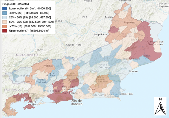
Source: Authors’ own elaboration with GeoDa, data from SEDEC/MDR.
Climate change has definitively moved onto the public policy agenda considering the permanent nature of the impacts that it will possibly imply for the localities’ future. Therefore, adapting is a vital condition to respond to these effects, which from now on will become more and more frequent and severe. Local and regional planning is essential for successful prevention and relief action, especially regarding those who are more vulnerable.
This study aims to investigate the impact of public policies of prevention, mitigation, and relief in Rio de Janeiro state’s municipalities in the period (2013-2022) over the affected people (number of dead, injured, missing, homeless, displaced and evacuees). Among the explanatory variables included are the budgeted and spent values on prevention works related to climate disasters, affordable housing programs for poor people, mayor political bias, government direct transfers, which indicate the amount of poverty in each municipality, and precipitation.
Municipalities with the highest vulnerability are those that, firstly, have physical characteristics more susceptible to disasters, such as mountains, valleys, rivers that easily overflow with rainfall, slopes that are susceptible to landslides, etc. Naturally, meteorological data like precipitation, temperature average, and altitude are also included, as well as other control variables, such as the city’s population. Secondly, human land occupation is crucial in determining the potential and effects scale of disasters. Irregular land occupation in cities is mainly caused by the housing deficit and the multiple economic crises that have dragged on since 2013 in Brazil.
Thus, people who have been directly affected, over the last decade, by an income reduction, due to rising unemployment, have had their condition of vulnerability increased. Many people were no longer able to pay their rent and were forced to live in poor conditions, many of them in risky areas.
In this way, we can deduce that poverty exerts a multiplicative effect on affected people in a climate disaster since most of them will be the poorest. Therefore, we use the “Bolsa Família” Programme, government direct cash transfers to people below the poverty line, as a proxy for poverty and vulnerability.
After estimating various types of panel data models, preliminary results show that if disaster prevention investments are made in a municipality in one year, this leads to a reduction in the number of people affected in the following year. These investments include drainage works, hill sealing, and river dredging, for example. Likewise, municipalities that provided affordable houses to low-income citizens in one period were able to reduce the number of people affected by natural disasters in the following year.
Regarding political bias, we found a correlation between natural disasters and left-wing municipality governments. That is to say, the higher the number of affected people in a municipality, the greater number of poor people living in that municipality and, thus, the greater the likelihood that a left-wing mayor will govern it.
Analyzing the two maps of Rio de Janeiro state in Figures 2 and 3, we can observe firstly that the mountain chain crosses the state, imposing a barrier to rainfall in the countryside. It makes the area vulnerable to large amounts of rainfall. Secondly, the first map shows a comparison between the risk areas mapped by the civil defence agencies. The second map presents the areas occupied by favelas or sub-normal housing settlements. It is interesting to note that areas are almost totally coincidental.
Figure 2. Risk areas in Rio de Janeiro State.
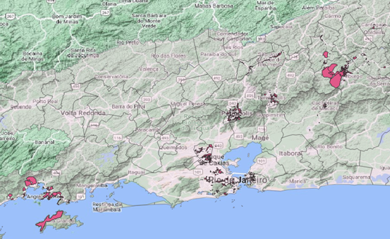
Source: Instituto Brasileiro de Geografia e Estatística (IBGE).
Figure 3. Favelas in Rio de Janeiro State.
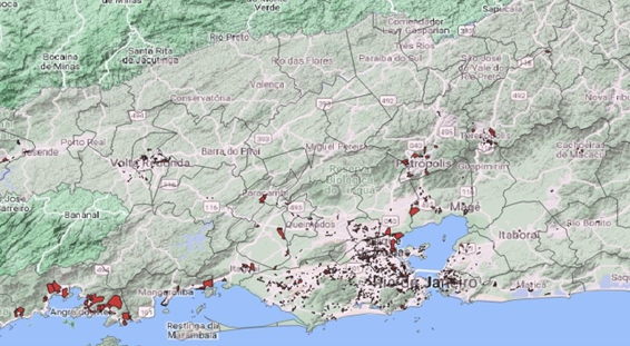
Source: Instituto Brasileiro de Geografia e Estatística (IBGE).
Therefore, we can assume that extreme weather events caused by climate change are a problem that affects people differently according to their economic status, impacting the poorest disproportionately. In contrast, people from more privileged economic groups are affected marginally and with lower intensity.
References
CEPED, U. (2013). Atlas brasileiro de desastres naturais: 1991 a 2012. Centro Universitário de Estudos e Pesquisas sobre Desastres, Federal University of Santa Catarina, Florianópolis.
COPPE (2018). Plano de Adaptação Climática do Estado do Rio de Janeiro. Centro Clima COPPE/UFRJ. Dezembro de 2018.
IBGE (2023) Instituto Brasileiro de Geografia e Estatística. Acesso em: 15 de Nov. 2022.
Fundação Oswaldo Cruz (Fiocruz). (2014). Mapa da Vulnerabilidade da População dos Municípios do Estado do Rio de Janeiro Frente às Mudanças Climáticas.
Mundial, B. (2012). Avaliação de perdas e danos: inundações e deslizamentos na Região Serrana do Rio de Janeiro. Janeiro de 2011. Brasília: Banco Mundial.
About the authors
Thierry Molnar Prates is Associate Professor III at the Federal Rural University of Rio de Janeiro – UFFRJ. Professor at the Postgraduate Program in Regional Economy and Development at UFRRJ. Post-Doctorate in progress at the Universidad Autónoma de Madrid – UAM (Spain).

Coro Chasco is RSA Ambassador to Spain, professor in the Department of Applied Economics at the Autonomous University of Madrid, and co-editor of Spatial Economic Analysis. She is a researcher in spatial econometrics applied to the analysis of regional inequalities, quality of life and environment.